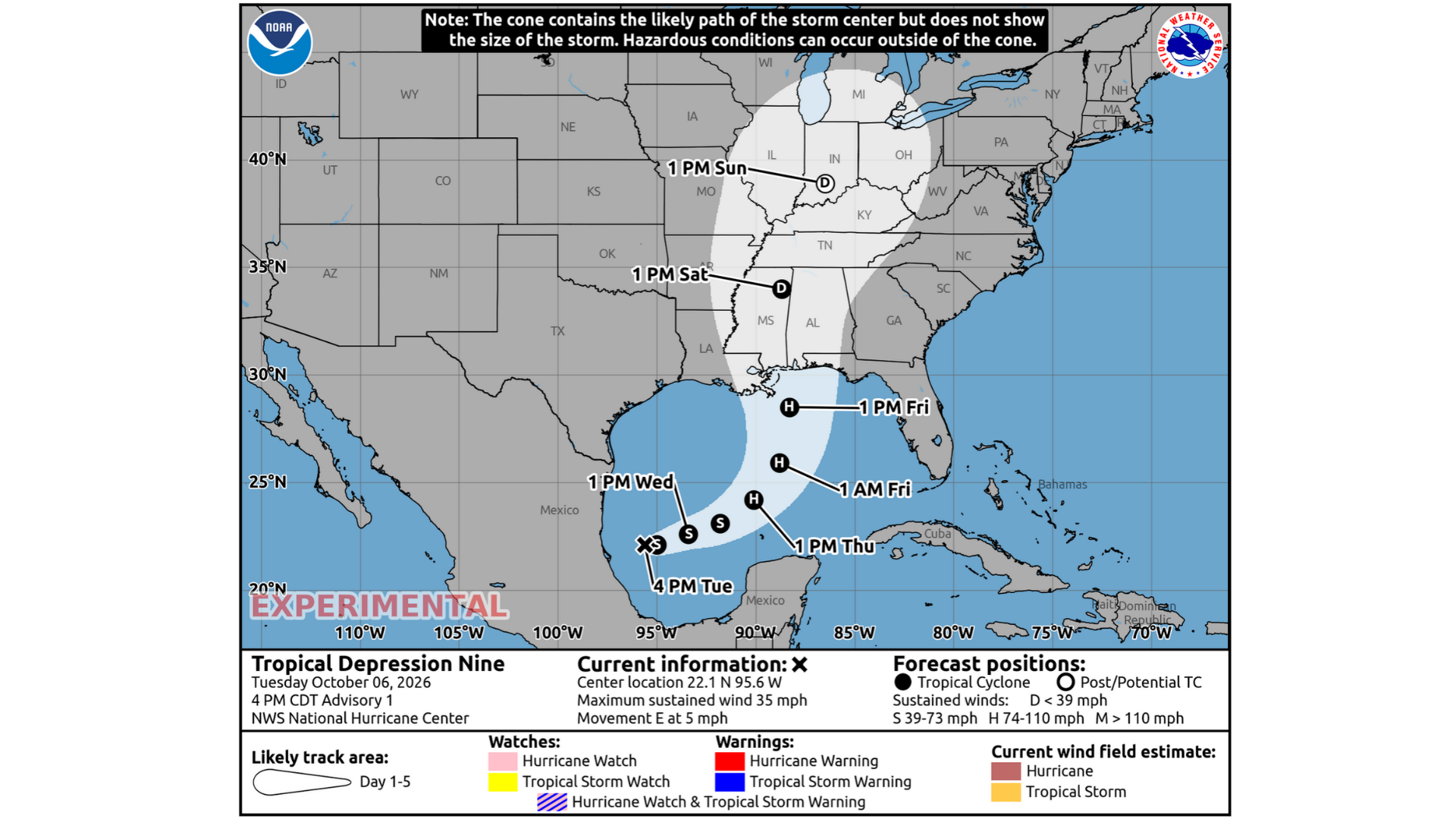
MERIDIAN, Miss. (Queen City Newsfeed) – A new storm formed in the Gulf of America on Tuesday afternoon. The National Hurricane Center calls it Tropical Depression Nine. Forecasters think it will grow into a hurricane and head toward the northern Gulf Coast by Friday.
The hurricane center put out its first report on the storm at 4 p.m. Tuesday. It is the ninth storm of this year’s hurricane season.
How the Storm Formed
The storm started as an area of low pressure in the southwestern Gulf, off the coast of Mexico. On Tuesday, satellite pictures showed it had started to spin around a center. Its rain and storms also became more organized. That is when forecasters named it a tropical depression.
Right now, the storm has winds of about 35 mph. It has barely moved in the past several hours.
The Storm Is Expected to Get Stronger
The water and weather in the Gulf are good for storm growth right now. Because the storm is small and tight, forecasters expect it to get stronger day by day.
Here is what forecasters expect:
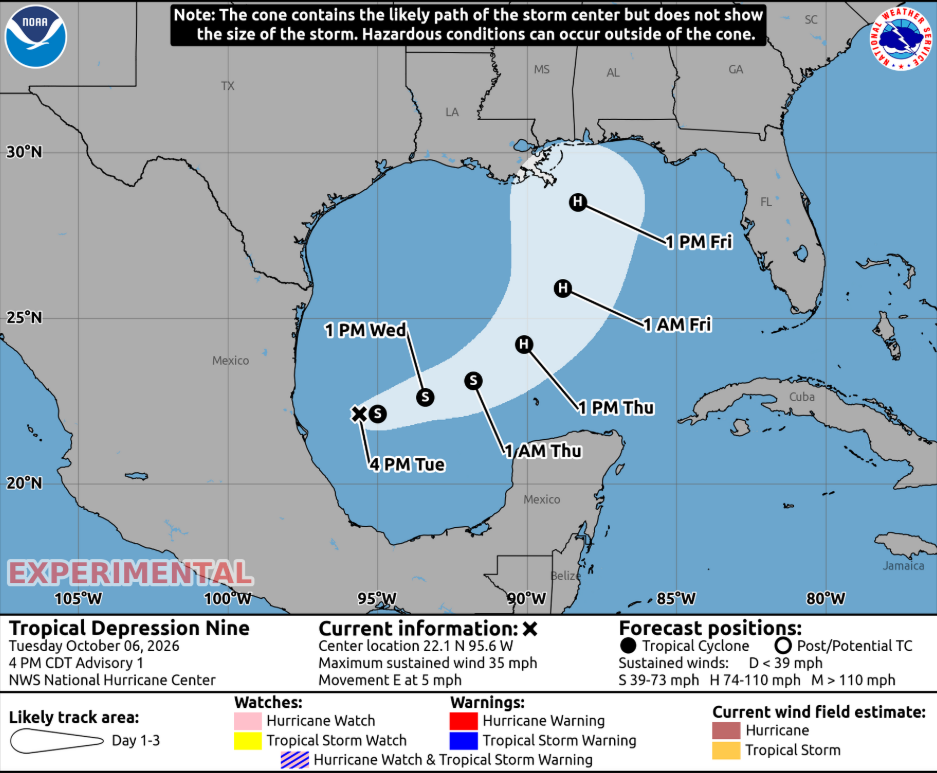
- Wednesday: The storm becomes a tropical storm and gets a name.
- Thursday: The storm becomes a hurricane.
- Friday afternoon: The storm has winds near 100 mph in the Gulf, south of the Mississippi and Alabama coast.
Forecasters think the storm will be at its strongest before it reaches land. Winds high in the sky may weaken it a little near the coast. Even so, forecasters say it should still be a dangerous hurricane when it comes ashore.
Some computer models even show a stronger storm than the official forecast.
Where the Storm Is Headed
For the next couple of days, the storm will move slowly east. It could bring wind and heavy rain to part of Mexico on Thursday.
Then on Friday, forecasters expect the storm to make a sharp turn to the northeast. Weather patterns over Texas and the Atlantic Ocean will push it that way. Those patterns should also make the storm speed up. It could reach the northern Gulf Coast late Friday or early Saturday.
After that, the forecast path takes the storm north through Mississippi. By Saturday afternoon, forecasters expect a much weaker storm over northeast Mississippi, with winds near 35 mph.
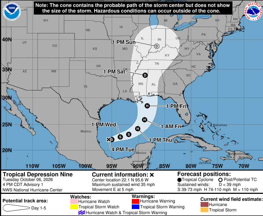
The Forecast Could Still Change
Forecasters say they are not sure yet about the storm’s exact path. They do not know exactly where it will turn or how fast it will move. Also, a stronger storm will likely move faster.
To get better answers, a NOAA hurricane hunter plane is flying near the storm to collect data. Weather balloons are also going up across the southern United States. This information should help forecasters make better predictions.
The storm will also likely grow much bigger as it gets close to land. It should spread out most on its eastern side. Because of this, forecasters say people should not focus on one exact spot on the map. Bad weather can reach far from the center.
What You Should Know
The National Hurricane Center shared three main points Tuesday:
1. Wind and storm surge danger is growing. Parts of the northern Gulf Coast face a rising risk of strong winds and storm surge. Storm surge is when ocean water gets pushed onto land. Officials could put out watches as soon as Wednesday. People from Louisiana to the Florida Panhandle should keep checking the forecast and have a hurricane plan ready.
2. Heavy rain could cause flooding. The storm will bring heavy rain to the central Gulf Coast from Friday into the weekend. Flash flooding and flooding in towns and cities could happen. Some rivers could also flood.
3. Mexico could feel it first. The storm could bring wind and heavy rain to the western part of Mexico’s Yucatan Peninsula in a couple of days.
Queen City Newsfeed will keep watching Tropical Depression Nine and share updates as new reports come out.