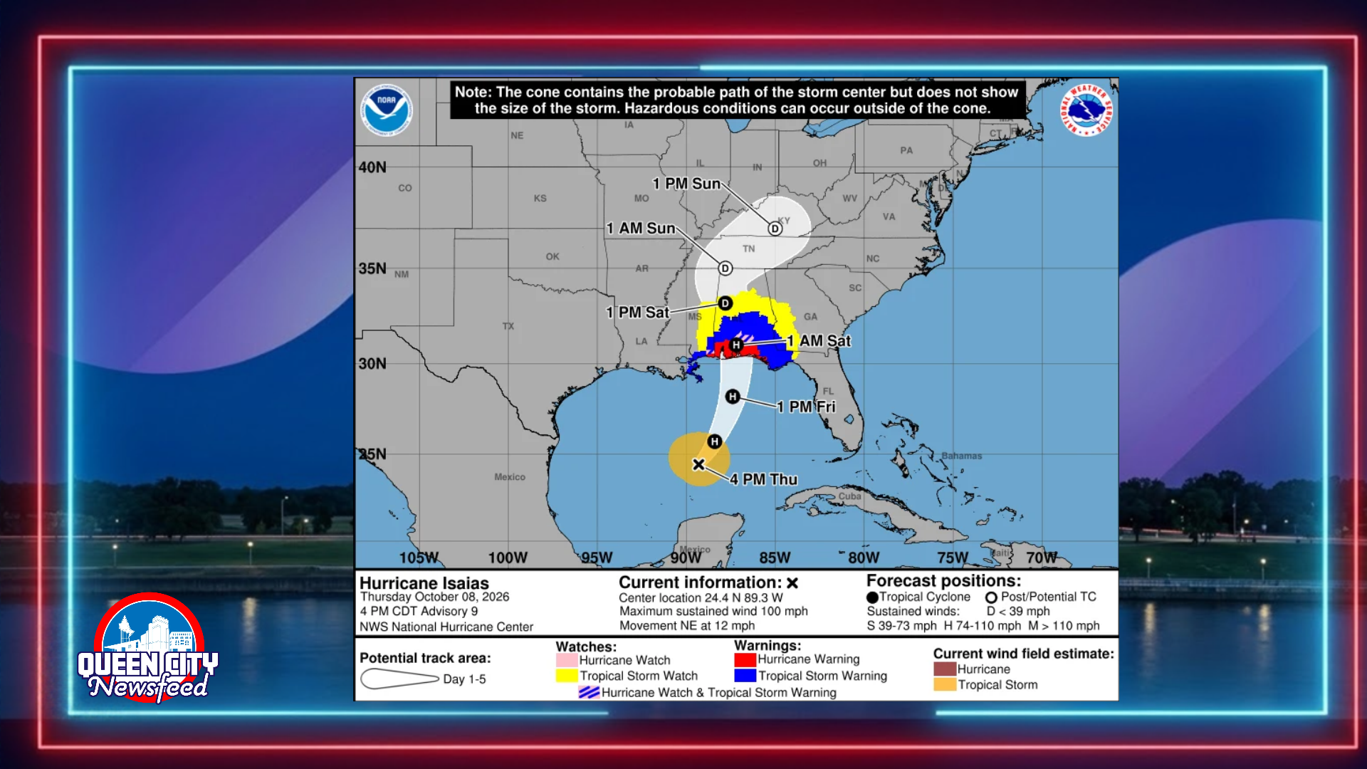
MERIDIAN, Miss. (Queen City Newsfeed), Hurricane Isaias grew stronger Thursday afternoon, and forecasters now expect its effects to reach well inland. The National Weather Service in Mobile has placed Wayne County, Mississippi, and several west Alabama counties under tropical storm alerts ahead of the storm’s expected landfall late Friday or early Saturday.
Tropical Storm Warning for Clarke County, Alabama
Clarke County, Alabama, faces the most serious local threat. Forecasters issued a Tropical Storm Warning for Jackson, Thomasville and Grove Hill.
The weather service expects sustained winds of 25 to 35 mph there, with gusts up to 50 mph. However, forecasters say winds between 58 and 73 mph remain possible. They urge residents to prepare for significant wind damage, including roof damage, snapped trees and blocked roads.
Flooding poses an even bigger danger. Clarke County could see 3 to 6 inches of rain, with higher totals in some spots. A Flood Watch is in effect, and forecasters say the flooding threat increased since their last update. They warn that major flooding could force evacuations and rescues, wash out roads and bridges, and send water into homes.
Tropical Storm Watch for Wayne County, Mississippi
Closer to home, a Tropical Storm Watch covers Wayne County, including Waynesboro. A watch means tropical storm force winds are possible within the next 48 hours.
Forecasters expect winds of 10 to 20 mph in Wayne County, with gusts near 40 mph. Still, they say winds of 39 to 57 mph cannot be ruled out. Residents should expect downed limbs, scattered power outages and damage to porches, carports, sheds and unanchored mobile homes.
Wayne County could also receive 1 to 3 inches of rain, with locally higher amounts. As a result, creeks and ditches may overflow, and some roads may close. Forecasters do not expect tornadoes in Wayne County at this time.
Wayne County Emergency Management can be reached at 601-735-2185.
West Alabama Counties Also Under Watches
In addition, Tropical Storm Watches cover six west Alabama counties along the state line:
- Sumter County (Livingston): Gusts near 40 mph and 2 to 4 inches of rain under a Flood Watch.
- Choctaw County (Butler, Lisman, Silas): Gusts near 35 mph and 3 to 6 inches of rain under a Flood Watch. Forecasters lowered the wind threat here since their last update.
- Marengo County (Demopolis, Linden): Gusts near 45 mph, 2 to 4 inches of rain and the chance of a few tornadoes.
- Hale County (Greensboro, Moundville): Gusts near 45 mph, 2 to 4 inches of rain and the chance of a few tornadoes.
- Greene County (Eutaw): Gusts near 40 mph and 2 to 4 inches of rain.
- Pickens County (Carrollton): Gusts near 40 mph and 2 to 4 inches of rain.
Clarke County, Alabama, residents can call their county EMA at 251-275-8775. Choctaw County, Alabama, residents can reach their EMA at 205-459-2153.
Residents of Lauderdale, Neshoba and other nearby Mississippi counties should monitor updates from the National Weather Service office in Jackson.
Latest from the National Hurricane Center
As of 4 p.m. Thursday, Hurricane Hunters found that Isaias had strengthened to 100 mph sustained winds. That makes it a Category 2 hurricane. The center sat about 325 miles south of the mouth of the Mississippi River, moving northeast at 12 mph.
Forecasters expect Isaias to turn north on Friday and strengthen further before it nears the coast. The National Hurricane Center says the storm should remain dangerous as it approaches Friday night. Hurricane force winds extend 15 miles from the center, while tropical storm force winds reach out 125 miles.
A Hurricane Warning stretches from Ocean Springs, Mississippi, to the Bay and Gulf County line in Florida. Meanwhile, a Tropical Storm Warning covers the Mississippi coast west of Ocean Springs and southeast Louisiana. Forecasters expect storm surge of 5 to 7 feet from Ocean Springs to Indian Pass, Florida, including Mobile Bay.
Tropical storm conditions should begin along the coast Friday, followed by hurricane conditions Friday night into early Saturday.
Heavy Rain Expected Across the Region
The hurricane center expects 4 to 8 inches of rain across southern Alabama, the Florida Panhandle and southwest Georgia, with up to 15 inches in some areas. Much of the rest of the Southeast could see 1 to 3 inches. Forecasters warn that flash flooding and river flooding are likely.
The National Hurricane Center will release its next update at 7 p.m. Thursday, with a full advisory at 10 p.m.
Queen City Newsfeed will continue to follow Isaias and bring you updates as conditions change.