MERIDIAN, Miss. (Queen City Newsfeed), Hurricane Isaias grew stronger over the Gulf on Thursday. Forecasters warn its damaging winds could reach well into east Mississippi after the storm comes ashore late Friday or early Saturday.
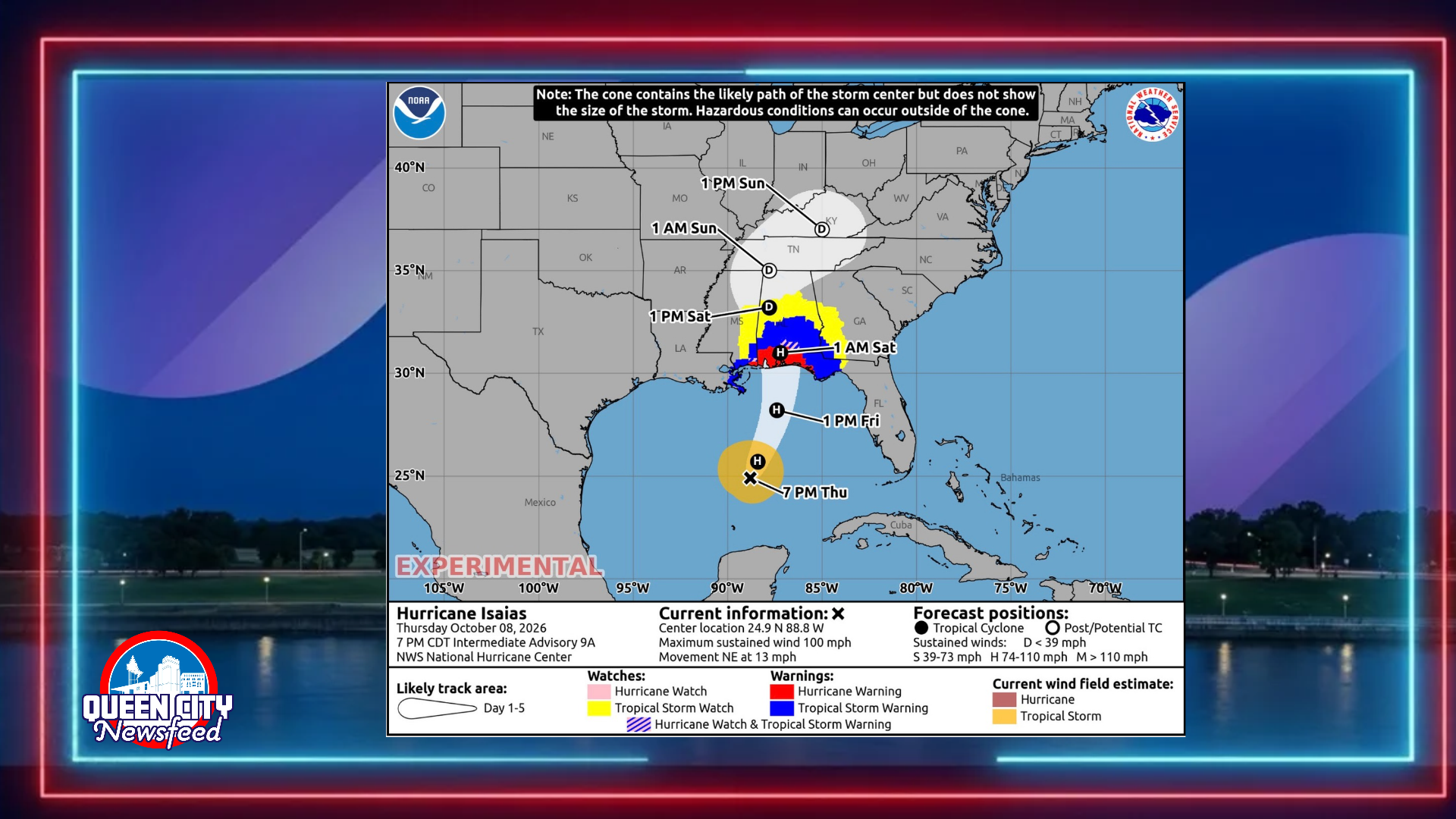
At 7 p.m. Thursday, the National Hurricane Center placed the center of Isaias about 290 miles south of the mouth of the Mississippi River. The storm had maximum sustained winds near 100 mph, which makes it a Category 2 hurricane. It moved northeast at 13 mph, and its minimum central pressure measured 974 millibars.
Forecasters expect more strengthening overnight. The hurricane center’s forecast calls for winds near 110 mph early Friday. After that, stronger wind shear should weaken the storm somewhat before landfall. Even so, forecasters said Isaias will remain a dangerous hurricane when it reaches the coast.
First Eye of the Season
Isaias formed a visible eye on satellite images Thursday afternoon. According to the hurricane center, this marks the first eye seen on satellite images in the Atlantic basin during the 2026 hurricane season. Hurricane Hunter aircraft also measured winds just above the surface that supported raising the storm’s strength.
Where Isaias Is Headed
Forecasters expect Isaias to turn north on Friday. The official forecast track brings the center inland near the Alabama and Florida state line around 1 a.m. Saturday, with winds near 75 mph. The center then moves north through west Alabama on Saturday and weakens quickly over land.
That path keeps the center east of Meridian. However, the storm covers a wide area. Tropical storm force winds extend up to 125 miles from the center, and forecasters said strong, gusty winds will reach well inland after landfall.
What It Means for Our Area
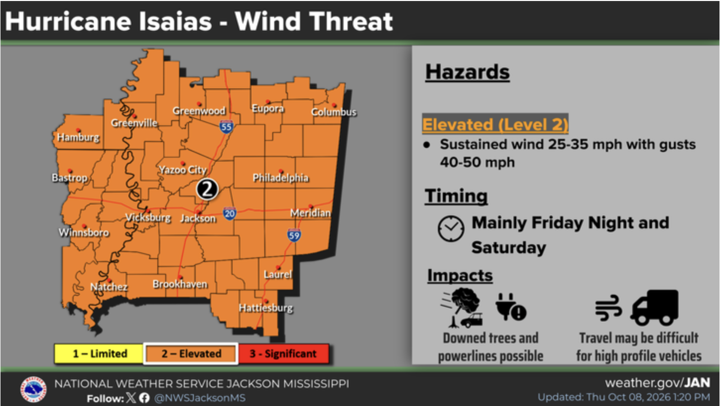
The hurricane center specifically named extreme eastern Mississippi among the areas where damaging wind gusts are possible. That list also includes central and northern Alabama and parts of Georgia. Forecasters said additional tropical storm and high wind watches or warnings may be needed for parts of that region Thursday night.
The hurricane center urged residents to secure loose outdoor items and avoid driving high profile vehicles. That means bringing in patio furniture, trash cans and decorations, and keeping box trucks and campers off the road during strong winds.
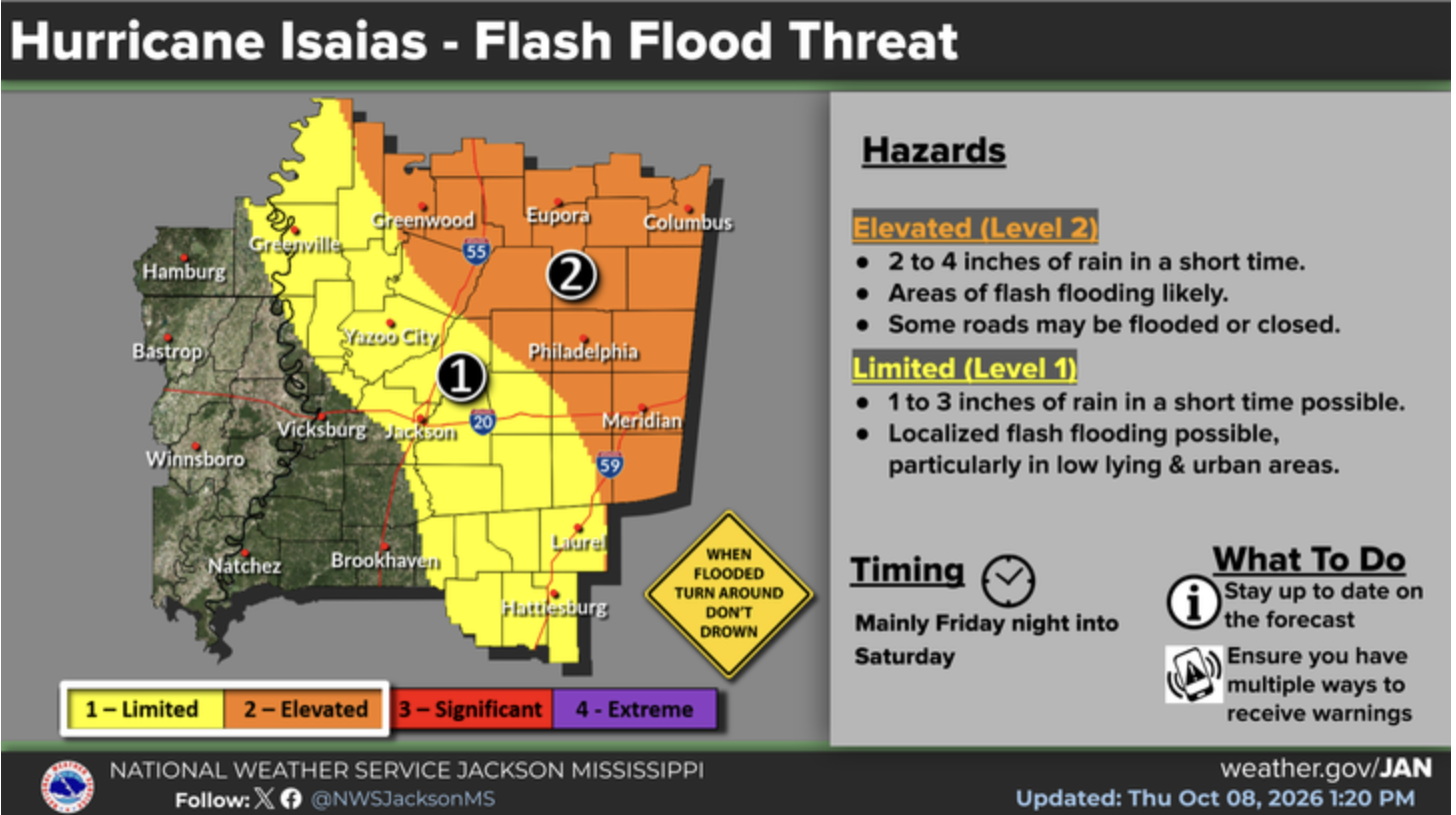
Rain also poses a threat. Forecasters expect 1 to 3 inches of rain across much of the Southeast this weekend, with some spots getting up to 5 inches. Flash flooding remains possible, especially in low areas and places with poor drainage.
Coast Under Hurricane Warning
Conditions will be far worse along the coast. A Hurricane Warning covers the area from Ocean Springs east to the Bay and Gulf County line in Florida. A Tropical Storm Warning covers the rest of the Mississippi coast west of Ocean Springs.
A Storm Surge Warning stretches from the mouth of the Mississippi River to the Suwannee River in Florida. If the peak surge arrives at high tide, water could rise 5 to 7 feet above ground from Ocean Springs to Indian Pass, Fla., including Mobile Bay. From the mouth of the Mississippi River to Ocean Springs, surge could reach 3 to 5 feet.
The hurricane center urged coastal residents to follow instructions from local officials and leave immediately if told to evacuate. Families with loved ones on the coast should check on them before conditions worsen Friday.
Stay Informed
The National Hurricane Center will issue its next full advisory at 10 p.m. Thursday. For local watches and warnings, residents in Lauderdale, Neshoba and surrounding counties should monitor the National Weather Service office in Jackson.
Queen City Newsfeed will continue to update this story as Isaias approaches.